Case Studies Websites Books Journals
"Tell me and I'll forget;
show me and I may remember;
involve me and I'll understand."
-Quote from the website of the Mapping for Change International Conference on
Participatory Spatial Information Management and Communication
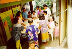
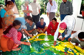
This quote exemplifies the underlying intention of Public Participation GIS (PPGIS): providing access to the opportunity to participate in decision making processes using GIS technology to groups in communities that normally would not have this opportunity.
What is a Geographic Information System (GIS)? GIS is a system of hardware and software used for storage, retrieval, mapping, and analysis of geographic data. All spatial data is geographically referenced to a map projection in an earth coordinate system; thus data from various sources can be brought together into a common database and integrated using GIS software.
Public Participation Geographic Information Systems is only one branch of GIS. It is a fairly new idea, gaining momentum within the past 15 years. At its core, it asks socially conscious questions regarding the production, use, access and representation of information used in GIS . GIS is both seen as a powerful tool for empowering communities and as an invasive technology that advantages some people and organizations while marginalizing others. It has been realized that GIS has the potential to have empirical, undemocratic tendencies. The goal of PPGIS, then, is to explore how ‘high technology information management tools can be brought into the public forum in a way that fosters fairness and increases decision-making competence rather than increasing polarization and marginalization.’ (T.C. Meredith et al., 205)
There is interest from a wide range of social, political and environmental contexts in linking community participation and GIS. The following are some examples of how PPGIS is being investigated:
As the field of PPGIS is fairly young, the body of literature concerning PPGIS methodology is still expanding. In addition, it is only within recent years that case studies have been undertaken and researchers have been able to distil ideas about good practice and effective implementation. The field is rapidly evolving and changing. There have even been suggestions from academics that the term PPGIS and inital thinking is actually difficult in implementation; some have proposed the term CiGiS (Community-Integrated GIS). For the purpose of this site, I will use the term ‘PPGIS’, with an understanding that this term may not be the most current or relevant term available.
This website provides an introduction to PPGIS. It is composed of a number of resources: case studies, journals, books, and websites. The goal of this site is to provide resources from which a more in-depth, specific investigation can occur.
References from this page can be found on the Book link or Website link. All images for this site sourced from www.iapad.org