Home Page Books Journals Websites
Case Studies of PPGIS
Case Study One: Using PPGIS to Locate a Nuclear Waste Disposal Site in Britian
Go to website
In this example, GIS is used to involve community members in the location of a nuclear waste disposal site in Britian. It is a web-based approach, using the internet to inform the participant of the situation and the role they play in the decision making process.
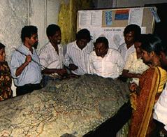
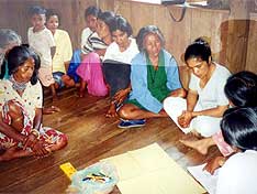
Case Study Two: PPGIS for Land Reform in Mpumalanga, South Africa
View PowerPoint Presentation
This case, also the basis for a chapter in the book Community Participation and Geographic Information Systems and the articles by Weiner, discusses the use of GIS technology in implementing land reforms in Mpumalanga, a province in northeastern South Africa.
Case Study Three: The Aboriginal Map Network (AMN)
Go to website
The Aboriginal Mapping Network has become a valuable strategic resource for practitioners of traditional knowledge mapping around the world. The AMN supports aboriginal and indigenous peoples facing issues such as land claims, treaty negotiations and resource development, with common tools, such as traditional use studies, GIS mapping and other information systems.
Case Study Four: PPGIS Use for Conflict Resolution in Balbalan, Kalinga, Philippines
Go to PDF Report